 Observation
 Celestial Mechanics Definitions List
As seen from Earth stars and deep sky objects seems to surround us, as Sun, Moon, and planets seem to move on the background of them. To report about this, to locate and to observe, astronomers built concepts, grids, and tools. Sky is mainly seen as a celestial sphere on which stars and deep sky objects are fictitiously seen affixed. This sphere has appropriate coordinate systems. Sun, Moon, and planets are journeying along this sphere, among stars. Here is a basic definitions list about this. Definitions are in alphabetical order. as far as remarkable positions of planets in the solar system are concerned, check more with our tutorial "Planets Apparent Motion"
- Anomalistic (Period)
- A planet's orbital period in the solar system as defined by two passages of it at perihelion
- Aphelion
- The point of Earth's orbit where the Earth is farthest from the Sun
- Apogee
- The point of the Moon's orbit where Moon is farthest from the Earth
- Ascending Node
- The point of a celestial object's orbit in the solar system where it passes from the southern, to the northern side of the ecliptic
- Celestial Meridian
- Imaginary circle passing just overhead the observer. Starting and ending points are depending on the observer's location at Earth. In the northern hemisphere the celestial meridian begins on the northern horizon, passes through the north celestial pole, then overhead the observer (or zenith). The celestial meridian ends at the southern horizon. Things are reverted in the southern hemisphere. In the equatorial regions, the celestial meridian starts and ends at the northern and southern horizon respectively that is at either celestial poles. The celestial meridian defines where celestial objects are reaching their highest point in the sky relative to observer. Due to Earth's rotation, any celestial object is seen rising on the eastern horizon, reaching observer's meridian, and setting on the western horizon. Due to Earth's motion around the Sun, celestial objects are passing at observer's meridian 4 mn earlier each night, i.e. 2 hours earlier each month (this means that each day, Earth is progressing by 4 minutes of arc on its orbit, and 30° each month)
- Celestial Sphere
- The celestial sphere is the theoretical sphere on which stars seem affixed and onto which Sun, Moon, and planets' motions seem to take place. The celestial sphere somehow is the terrestrial globe's projection onto the sky. Hence it has a north and a south poles (north and south celestial poles are terrestrial north and south poles' continuation) and an equator (which is the terrestrial equator's projection). For the purpose of locating celestial objects on the celestial sphere the latter is subject to various coordinate systems. Most used by amateur astronomers is the 'equatorial coordinate system' (see at Coordinate systems)
- Conjunction
- Particular position of a planet on its orbit, relative to Earth. Superior planets (that is planets beyond Earth) are at conjunction when they are on a line Earth-Sun, on the other side of the Sun relative to Earth. Inferior planets (that is planets orbiting between the Sun and the Earth) have two kind of conjunctions, inferior and superior. An inferior planet is at inferior conjunction when it's located on a line Sun-Earth, just between Sun and Earth; it's at superior conjunction when it's on a line Earth-Sun, on the other side of the Sun relative to Earth. Conjunctions are part of the yearly positions of planets relative to Earth
- Coordinate Systems
- For the purpose of locating celestial objects on the celestial sphere astronomers has deviced diverse spherical coordinate systems. These systems are mostly similar to Earth's latitude and longitude system. All of them have a 'main axis', two poles, and a 'main reference circle'. Main axis, or polar axis, is the system's rotational axis. Two poles are where main axis intersects sphere. Main reference circle -or 'great circle"- is the system's equator. It is perpendicular to the main axis. Equivalent of latitudes are measured each side of main reference circle. Equivalents of longitude are measured starting at a point defined on the main reference circle. Secondary circles (they are also said 'main circles' too) -the first one beginning at this point of origin- are passing at system's both poles and are used to define objects longitude. For professional astronomical purposes, there are four coordinates systems: horizontal, equatorial, ecliptical, galactical. Amateurs mainly use the equatorial system and instinctively use the horizontal one. Ecliptical and galactical systems' main axis are ecliptic or galactic (Milky Way) north-south pole axis; their main reference circle are ecliptic or the Galaxy's plane respectively. Both have a coordinates units system: a 0°-360° system measuring 'celestial longitudes' and 'galactic longitudes'; a +90° / 0° / -90° system measuring 'celestial latitudes' and 'galactic latitudes"
- Descending Node
- The point of a celestial object's orbit in the solar system where it passes from the northern, to the southern side of the ecliptic
- Draconitic (Period)
- A planet's orbital period in the solar system as defined by two passages of it at the same node of the orbit
- Ecliptic
- The ecliptic is Earth's orbit's plane. Projected on the celestial sphere, the ecliptic is a line along which Sun, Moon, and planets' apparent motions seem to occur. See too 'Zodiac'
 | Celestial equator (white line) is Earth's equator projected on celestial sphere. Ecliptic is projected Earth's orbit plane (orange line). Zodiac (blue) is due to planets' orbits inclination relative to ecliptic yielding their apparent motion to vary by 8° either side of the latter. North is up |
Due to the tilt of the Earth's poles axis, which is remaining steady as Earth is orbiting the Sun, the ecliptic, by midday for the observer is lying at a varied position function of the seasons. By the winter solstice, the ecliptic is symmetrically lying under the celestial equator; by the summer solstice, at the reverse, it is symmetrically lying above the celestial equator. By both equinoxes, the ecliptic is crossing the celestial equator
- Equator (or Celestial Equator)
- It's the projection of the terrestrial equator on the celestial sphere. Celestial equator is intersecting the ecliptic at two points. These points are named the vernal and the autumnal equinoxes (about equinoxes, see the tutorial 'Seasons"; about the vernal equinox see below)
- Equator (Terrestrial Equator)
- On Earth, the equator is the line of latitude 0° which delineates the northern and southern hemispheres. At the vernal and autumnal astronomical equinoxes (that is mostly on the days of spring and of fall), Sun, at the equator, is directly overhead at noon
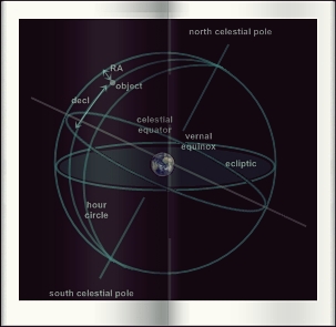
- Equatorial Coordinate System
- The equatorial coordinate system is one of the coordinates systems used about the celestial sphere. Simply said this system is a projection of Earth's coordinates on the celestial sphere. The main axis (or polar axis) of the equatorial system is the celestial sphere' axis. Hence its north and south poles are the north and south celestial poles. Its main reference circle is the celestial equator that is the terrestrial equator's projection on the celestial sphere. 'Longitudes' of celestial objects are measured on the celestial equator, starting at the vernal equinox. The vernal equinox is the point where Sun is at the spring equinox (more simply on spring's day). Terms 'right ascension' are used for celestial objects instead of 'longitude'. Right ascension is abbreviated 'R.A.'. Right ascension is measured eastwards using a time units system. Equator is divised in hour, minutes and seconds. This system appeared natural as celestial sphere' apparent rotation is taking one day. They are 24 R.A. circles (or 'hour circles"), passing at the system's poles. First circle originates at vernal equinox. Each one R.A. hour is divided into 60 minutes. Each minute is divided into 60 seconds. Each R.A. hour equals 15° as the celestial sphere equals 360°. Each R.A. minute is 4 arcminutes. On the other hand, the 'latitudes' of celestial objects are measured each side of the celestial equator, north, or south, using a +90° / 0° / -90° system. 'Declination' is used instead of 'latitude'. Declination is abbreviated 'dec.'. The equatorial coordinate system is affixed to the celestial sphere. It rotates with it. Due to the precession of the equinoxes, Earth's equinoxes are slowly shifting. As vernal equinox is part of them and as it is the point of origin of the right ascension system the catalogs of stars have to be updated periodically. Shift is about 50" per year. Catalogs are modified about each 50 years. One consequence of this is that the celestial objects' equatorial coordinates are given for such or such vernal equinox position. Present reference is termed 'J2000.0'. Equatorial coordinate system used by professionals is technically a dynamical system based on the definition of its equator and its point of origin by reference to Earth's motion, complemented with a set of 1,535 bright stars (this set is said 'Fifth Fundamental Catalogue (FK5)"). This system is in way of being improved at the International Astronomical Union (IAU) by a new one, the 'International Celestial Reference System' (ICRS). ICRS is aiming at being independent from any Earth-linked dynamical reference. ICRS defines equator and equinox in reference to very accurate positions of 608 extragalactic radiosources. A subset of the Hipparcos Catalogue (said the Hipparcos Celestial Reference Frame, HCRF) serves as the FK5 of the new system. Due to how modifications of the axis of Earth's rotation (precession-nutation) are to be computed is still unclear, UAI's ICRS has not yet been implemented as of late 2002. ICRS, for accuracy requirements of no more than 0.1 arcseconds near epoch J2000.0 will be totally transparent with J2000.0-FK5 dynamical equator and equinox system
- Eastern Quadrature
- Moment when a planet is seen by 90 degree East from the Sun. The planet then is seen by the second part of night
- Greatest Eastern
- Elongation For a inferior planet -a planet located between the Earth and the Sun, its maximal elongation East, or largest angular distance from the Sun. It is the moment where the inferior planet is visible like a evening star for the longest time
- Greatest Western Elongation
- For a inferior planet -a planet located between the Earth and the Sun, its maximal elongation West. It is the moment where the inferior planet is visible like a morning star for the longest time
- Horizon
- The horizon is the line which, for a given location, is dividing the celestial sphere into a visible and an invisible celestial hemisphere
- Horizontal Coordinate System
- The horizontal coordinate system is one of the coordinates systems used about the celestial sphere. Simply said, the equator of this system is the observer's horizon. Main axis (polar axis) of the horizontal system is the observer's zenith-nadir axis. Main reference circle is the observer's horizon. It is called the 'astronomical horizon'. It features four main points: North, East, South, West. 'Longitudes' are measured on the main reference circle, clockwise, starting North (which is the system's point of origin), using an angular units system (0-360°). 'Azimuth' is used instead of 'longitude'. North is at 0°, East at 90°, South at 180°, West at 270°. Secondary circles (which are said 'vertical circles") -first of them being located North- are passing by both poles and are helping defining objects' azimuths. 'Latitudes' are measured either side of astronomical horizon in a +90° / 0° / -90° system. Latitude of the objects is termed 'altitude'. This system is fixed relative to the observer only which means that the celestial sphere is seen rotating beyond the horizontal system coordinates grid. When professionally used such a system needs an additional datum to be given: the time at the moment of the observation. The exact observer's location terrestrial coordinates are mandatory too. Amateur astronomers instinctively use horizontal system when they measure angles in the sky, e.g. when they try to figure out how high a celestial body like a planet or the Moon is above the horizon
- International Terrestrial Reference Frame
- The International Terrestrial
Reference Frame (ITRF) as managed by the Global Geodetic Observing System, a scientific
organization is the way the Earth reference frame is defined, allowing for a variety of systems to work, like, for example, the Global Positioning System (GPS). Data of the Earth's reference frame are collected from a variety of techniques, like the Doppler effect of some satellites, the GPS satellites themselves, interferometry -of which some to dozens of quasars, or laser ranging of some other orbiting craft. NASA and the international community under the form of geodetic administrations including Germany's Bundesamt für Kartographie und
Geodäsie, France's Institut Géographique National, the Geographical Survey
Institute of Japan, and Geoscience Australia upgraded the IRTF in January 2016. Officially called ITRF2014, the update is the ninth
ITRF issued since 1992. More than a thousand observing stations run by NASA and
other scientific institutions worldwide contributed to it, collecting data
through 2014. The ITRF is made up of specific
geographic positions around the world, along with information about how each one
drifts over time
- Line of Apsides
- A line joining both the perihelion and the aphelion of a planet in the solar system; the line of apsides is generally not fixed as it is affected with small precession motions
- Line of Nodes
- A line joining both the ascending, and the descending node of a planet in the solar system; the line of nodes is generally not fixed as it is affected with small precession motions
- Measurement of a Circle
- A circle can be divided into 360 degrees of arc (°), each degree being divided into 60 arcminutes ('), each minutes being divided into 60 arcseconds of arc ("). The main reference circle of a coordinate system is such a circle
- Nadir
- It's the point of celestial sphere which at the opposite of the zenith, relative to the observer (that is the point beneath observer's feet, extending at the infinity)
- Opposition
- Particular position of a superior planet on its orbit, relative to Earth. Superior planets are planets which are located beyond Earth. Such a planet is at opposition when it's on a line Sun-Earth, beyond Earth. It's the moment when a superior planet is at its best visible for observers, rising at sunset and setting at sunrise
- Perigee
- The point of the Moon's orbit where Moon is closest to Earth
- Perihelion
- The point of Earth's orbit where the Earth is closest to the Sun
- Polar Circle
- The Polar Circle is a circle of coordinates parallel to the terrestrial equator, marking the limit whence, at the moment of the solstice, the day or the night have a duration of 24 hours. Either then the midnight Sun or the Arctic (or Antarctic) night are extant. The Arctic (or Northern) Polar Circle is found by 66° 33' of northern latitude, as the Antarctic (or Southern) Polar Circle is by 66° 33' of southern latitude. Both Polar Circles, with the Tropics, are constituting the main astronomical landmark lines reported unto the coordinates of the terrestrial sphere
- Precession of the Equinoxes
- The Earth's polar axis -the line which joins Earth's north and south pole- is tilted relative to Earth's orbit's plane (the ecliptic). This tilt (or inclination) is 23.5°. Due to the Sun and Moon's combined gravitational effects Earth polar axis is slowly moving clockwise, the way a spinning top's axis is slowly moving when the top is spinning. Such a motion is called the 'precession of the equinoxes'. The vernal and the autumnal equinoxes (the points where the ecliptic intersects the celestial equator) are slowly shifting westward each year due to the precession of the equinoxes. The shift is about 50" a year. It takes 26,000 years for the Earth's axis to complete a complete circle. This movement is explaining why Polaris has not always been the polar star nor will it always be. Nowaday, the Earth polar axis, projected on the celestial sphere, is pointing to the Polaris. 12,000 years ago it was to Vega. 5,000 years ago it was to a of the Dragon. Precession is inducing a change in celestial objects' equatorial coordinates, hence the equatorial coordinate system has to be re-defined about each 50 years
- Solstice
- That world originates in the Latin words 'sol' (the Sun) and 'stare' (to stop). The solstice is the point the farthest away from the celestial equator. Two solstices are extant along the ecliptic as the line joining both is a perpendicular to the one joining both equinoxes. For the mid-latitudes, the summer solstice is when the Sun, at midday, is reaching its year's highest in the sky as the winter solstice is when the Sun, at that time, is reaching its year's lowest. Both solstices are too part of the phenomenon of the seasons (see a tutorial about seasons)
- Tropics
- Tropics are the lines of terrestrial latitude 23° 27' North and South. Northern tropic is called the Tropic of the Cancer, southern is called the Tropic of the Capricorn. Tropics are defining an astronomical position, an astronomical event, and a climate zone. First, tropics are the northern and southernmost points where Sun is appearing directly overhead at least one day a year -which is occurring on the solstice day at noon. On this day only, Sun is overhead an observer there. Tropics are an astronomical event too. When Sun at the tropic is overhead an observer, it is summer solstice there, whatever the hemisphere (about solstices, see the tutorial 'Seasons"). At last, this height of the Sun is defining a climate zone. This zone is termed 'tropics'. It is a warm climate zone either side of the terrestrial equator where Sun is always high in sky. Due to the tilt of the Earth's poles axis terrestrial is usually divided into 5 main zones. The tropical zone each side of the equator and until the lines of tropics at 23° 27', which are all the areas on the Earth where the Sun is seen at the zenith by some periods in the year. The tropical zone features a hot climate because the Sun is often at the vertical. That zone represents 40 percent of the terrestrial surface. Then come both temperate zones which are located between the tropics and polar circles at the mid-latitudes; the Sun is never seen at the zenith as it rises and sets every day; their climate is temperate as sun rays are oblique most of the time and one differentiate seasons clearly; both the temperate zones cover 52 percent of the Earth. At last, both the polar zones which are delineated by the polar circles located by 66° 33' or the location where the angular distance to the poles is the value of tilt of the ecliptic, at 23° 27'; the Sun is staying under, or above the horizon during several days by the time of solstices; the climate is icy because sun rays are low-angled and that night extends over a whole part of the year. Both the polar zones equal 8 percent of the Earth. By the equator, the length of day equals that of night all year long, at 12 hours each
- Vernal Equinox
- It's the point where the celestial equator is intersecting the ecliptic. The ecliptic is the plane of Earth's orbit. It appears like a line, on the celestial sphere. The Sun, Moon, and planets' apparent motion on the celestial sphere is about that line. The vernal equinox is where Sun is about March, 21st i.e. on spring day, moving upwards. It's also the point of origin of the right ascension in the equatorial coordinate system applied to the celestial sphere. The vernal equinox has the autumnal equinox as its counterpart. Both equinoxes are too part of the phenomenon of the seasons (see a tutorial about seasons)
 | As seen from Earth -which is orbiting from left to right- ecliptic (yellow line) and celestial equator (blue) have variable positions relative to each other along year. North is up |
- Western Quadrature
- Moment when a planet is seen by 90 degree West from the Sun. The planet then is seen by the first part of night
- Zenith
- The zenith is the point of the celestial sphere which is directly situated overhead the observer. The opposite point is the "nadir"
- Zodiac
- The zodiac is a 16° wide belt which marks the northern- and southernmost boundaries (8° either side of the ecliptic) where Sun, Moon, and planets' apparent paths against the celestial sphere are seen taking place in relation to the ecliptic. The term 'zodiac' means 'circle of small animals' ('zodiakos kyklos') in Greek as all of its original constellations were figuring animals. That astronomical zodiac is constituted by 12 constellation, Aries, the Ram, Taurus, the Bull, Gemini, the Twins, Cancer, the Crab, Leo, the Lion, Virgo, the Virgin, Libra, the Scales, Scorpius, the Scorpion, Sagittarius, the Archer, Capricornus, the Goat, Aquarius, the Water Bearer, Pisces, the Fishes, in that order. Some recently took the habit, to point out that Ophiuchus, the Serpent Holder, is also part of the zodiac. That astronomical zodiac is originating from the astrological zodiac. The division of that area of the sky into 12 equal parts -or one to each month of the year- belongs to the practice of astrology -which was mostly developed by ancient Egyptians- and dates back to the 5th century B.C. as it is unknown whether they gave to each part the name of the constellation which lied there, or the reverse. It might well be it is that second solution to be true because the figures and limits of the constellations were very variable. Each part of the zodiac is 30 degree-wide as the vernal equinox (there where the Sun is to be found by the spring equinox) was then associated to Aries, the Ram and marked the start of the zodiac. Contemporary astrology still refers itself to that old zodiac. But, due to the precession of the equinoxes, current astronomical positions of the Sun, planets and Moon do not match with it anymore. Astrological signs and astronomical constellations will match by some 24,000 years from now only
Website Manager: G. Guichard, site 'Amateur Astronomy,' http://stars5.6te.net. Page Editor: G. Guichard. last edited: 2/27/2016. contact us at ggwebsites@outlook.com
