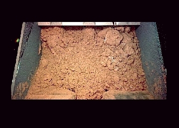
Martian Soil, Close-Up! This is a renewing sight! This picture is a close-up image of the soil of Mars! This picture has been taken recently by NASA's new Martian lander, the Phoenix mission. The Phoenix mission is a mission which landed at Mars, in the polar, northern plains and is now taking like an aim to study the soil there for potential habitats for water ice and to look for possible indicators of life, past or present. This is done through a robotic arm, about 7.7-foot (2.35-meter) long which digs into the ground, delivering samples to other instruments of the lander for further analysis. The arm can reach far enough to dig about 20 inches (half a meter) deep. The arm's scoop is provided with the 'Robotic Arm Camera' (RAC) mounted just above the scoop at the end of the arm, providing close-up color images of the soil's samples. This image was taken during the Phoenix lander's first test dig on June 1, 2008, seven days into its mission. The test sample shown here might show, on the right side of the image, possible ice or precipitated salts, under the form of the white patches seen. The Phoenix mission has a targeted duration of three months, as it landed last May 25th, 2008 in the northern region of Mars Vastitas Borealis, by 68° north latitude, and 234° east longitude. The scoop is about large like your hand, as the Martian soil there is about a small handful of it, with the picture brought back at scale by us. picture site 'Amateur Astronomy', based on a picture courtesy NASA/JPL-Caltech/University of Arizona/Max Planck Institute
 Du sol martien!
Vue inédite! Voici du sol martien en vue rapprochée! L'image a été prise par le nouveau lander martien de la NASA, le lander Phoenix. La mission Phoenix a atterri dans les plaines polaires nord de Mars, avec pour but d'étudier les sols à la recherche d'habitats potentiels de glace d'eau et d'y rechercher des indicateurs possibles de vie, présente ou passée. Le lander, pour ce faire, utilise un bras robotique qui, creusant le sol, en ramène des échantillons qui sont analysés ensuite par les autres instruments de la mission. Le bras est suffisamment long pour pouvoir creuser jusqu'à 0,50 m (20 pouces) dans le sol de Mars. Le godet, à l'extrêmité du bras robotique, est accompagné d'une caméra, la "Robotic Arm Camera" -RAC- qui est montée juste au-dessus des échantillons de sol, en permettant une vue rapprochée. L'image de ce premier échantillon prélevé par le lander a été prise lors du premier test de fonctionnement du bras robotique, le 1er juin 2008. L'image pourrait montrer soit de la glace, soit des sels précipités, qui seraient les patchs blancs vus sur la droite. La mission Phoenix a une durée initiale de trois mois pour accomplir sa mission. Le lander a atterri dans Vastitas Borealis, dans les régions polaires de Mars, par 68° Nord et 234° Est. Le godet du bras robotique fait à peu près la largeur d'une main humaine; aussi, le sol martien que l'on voit ici représente une petite poignée de sol. L'image est à l'échelle (nous l'avons, pour cela, redimensionnée de sa taille originelle). site 'Amateur Astronomy', sur la base d'une image NASA/JPL-Caltech/University of Arizona/Max Planck Institute
Website Manager: G. Guichard, site 'Amateur Astronomy,' http://stars5.6te.net. Page Editor: G. Guichard. last edited: 12/28/2010. contact us at ggwebsites@outlook.com