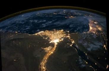
Egypt Seen at Night From the ISS. Astronauts aboard the International Space Station (ISS) pictured a classical concept concerning Egypt, a one illustrated here at night. That picture indeed is well showing how the population of the country is concentrated along the Nile Valley, the long ribbon stretching to the bottom center -and the Nile Delta too, that stretched illuminated area bordering to the Mediterranean Sea (centre). The Cairo metropolitan area, with Cairo the capital city of Egypt, forms the brightly lighted patch to the bottom of the delta. Scattered blue-grey clouds cover the southeastern Mediterranean and the Sinai, while much of northeastern Africa is cloud-free. The other major lighted area in the region, right, is Israel as the darker patch, to the bottom left of the image, is the Red Sea. The thin yellow-brown band tracing the Earth’s curvature at the top of the image, which is often seen on pictures taken at night from the ISS is airglow, a faint band of light emission that results from the interaction of atmospheric atoms and molecules with solar radiation at an altitude of approximately 60 miles (100 kilometers). courtesy site 'Amateur Astronomy' based on a picture NASA
 L'Egypte de nuit vue de l'ISS
Les astronautes de la Station Spatiale Internationale, l'ISS, ont représenté ici un concept classique qui concerne l'Egypte, concept illustré, là, de nuit: l'image montre bien comment la population égyptienne se concentre le long de la vallée du Nil, ce long ruban qui court au centre, en bas, ainsi que dans le delta du Nil (au centre de l'image), cette zone étendue, qui borde la Méditerranée. La zone urbaine du Caire, la capitale, est la zone fortement éclairée qui se situe au bas du delta. Des nuages bleu-gris épars couvrent le sud-est de la Méditerranée ainsi que la péninsule du Sinaï alors que l'essentiel de cette partie du Nord de l'Afrique est dégagé. L'autre principale zone illuminée, à droite est Israël et l'étendue sombre, en bas à droite, est la mer Rouge. La mince bande brune qui marque la courbure de la Terre, que l'on voit souvent sur les images prises depuis l'ISS, est le "airglow" (littéralement, "brillance de l'air"), une zone d'émission lumineuse résultant, vers 100 km (60 miles) d'altitude, de l'interaction entre les atomes et molécules de l'atmosphère avec le vent solaire. site 'Amateur Astronomy' sur la base d'une image NASA
Website Manager: G. Guichard, site 'Amateur Astronomy,' http://stars5.6te.net. Page Editor: G. Guichard. last edited: 5/12/2011. contact us at ggwebsites@outlook.com