| CONTENT - Most useful data about the current debate about the global warming. A tutorial in our series about the Earth |
The question of the ecology and of the fate of planet Earth began emerging in the 1970's and largely grew during those last years! From stances which were about preserving the living conditions of people and from the question of the too large increase in demographics, one has passed there -like in numerous other domains- to catastrophism, with ecologists stating that threats are threatening importantly the soleecological balance of our planet. What can be told more in details about all that?
->Most Recent Numbers
Most recent numbers concerning the climate change are the following. Global temperatures at Earth should have increased by 0.8°C since one century and are currently increasing by 0.1°C per decade. The U.N. report's
climate simulations predict a warmer and wetter Earth, with global temperature
increases of 3.6 to 7.2 degrees Fahrenheit (2 to 4 degrees Celsius) by 2100,
about the same warming that occurred following the Last Glacial Maximum almost
20,000 years ago, except about it is to unfold 100 times faster. Twice the quantity of carbon dioxine found during the pre-industrial times should be reached by the mid-21st century. A study by early 2012 found that Earth's clouds had decreased in height by around 100 to
130 feet (30 to 40 meters) in a decade, which could potentially slow the effects of global warming as allowing our planet to cool to space more efficiently. Most of the reduction was due to fewer clouds
occurring at very high altitudes
->Back to Warm?
A shift in the world of climate warming critics have occurred recently with most abandoning the idea that climate warming is a hoax and focusing now upon whether it is man-made or that any effort against is economically pointless. It looks like the idea should be accepted that global land temperatures increased by 1 degree Celsius since one century. Three sets of temperature data used to assert that are one maintained by NASA, one by the National Oceanic and Atmospheric
Administration (NOAA), and one by a collaborative effort between Britain's
Meteorological Office and the University of East Anglia's Climate Research Unit (referred to as HadCRU)
->Global Warming Questioned!
By late 2009 and early 2010, a 'climate-gate scandal' is developing with varied questions of false-reported or kept data, which question the existence self of any climate warming. A recent developement, by February 2010 has had the former head of the Climatic Research Unit (CRU) of the University of
East Anglia declared to the BBC that the average increase of 0.12 degree C per year over the last 15 years is quite
close to the significance level or that he had been a poor
record keeper for the globe's temperature
->The Shift of the Intertropical Convergence Zone Since 3 Centuries Likely a Major Factor to Climate Change!
A study found, in 2009, that the intertropical convergence zone-generated rain band, near the equator, moved North and South at an average rate of almost a mile (1.4 km) a year for three centuries, likely because of a warming world because of its impact on the atmospheric circulation patterns throughout the world. Trade winds from the northern and southern hemispheres just collide at the equator, where, with the evaporating heat from the oceans, they generate rain clouds up to 30,000 feet thick dump as much as 13 feet (4 meters) of rain a year in some places. During the Little Ice Age, between about 1400 and 1850, the rainy band might have been about the equator, as it moved North and South since, bringing areas which were wet, like the Galapagos, to become arid, or areas which were arid to become wet, like Palau, Pacific Ocean. Should the rate continue, the rainy tropical zone should keep shifting North, moving by about 75 miles (126 km) North by the second part of the 21st century! Such an accurate measurement is telling two things. One, that there is a 'natural' warming trend on Earth since the end of the medieval and Modern Times era Little Ice Age. Two, that this natural warming likely is translating into a number of climate and weather shifts since
What is called "global warming" is this trend which, since about 250 years, would be modifying the great balances of Earth's climate. A benevolent, natural greenhouse effect exists at Earth. As a part of sunlight is managing to reach through the atmosphere and clouds the Earth's surface, the Earth is heated. This heat is partly reflected under the form of infrared radiation. A part of this radiation is blocked by some of the gases which are naturally present in the atmosphere, like carbon dioxide, water vapor (the most important component and acting mostly in the upper troposphere), or methane. On the other hand, high-altitude, icy, cirrus clouds are another major actor as they may reflect Sun radiation, or trap the reflected infrared radiation, due to their icy crystals. Such a natural greenhouse effect is benefiting Earth. Without it Earth would endure temperatures 60° F (30° C) lower than the current ones, something like a Mars bound Earth... As the sun's rays shine on our planet, flat, low-altitude stratus clouds reflect most of this heat back into space, keeping Earth cool with their shade. At the same time, thin, wide cirrus clouds high in the atmosphere trap heat on Earth's surface, keeping the planet warm
Non-condensing greenhouse gases -- such as carbon dioxide, methane, nitrous oxide, ozone, and chlorofluorocarbons -- as providing the core support for the terrestrial greenhouse effect. Without such greenhouse gases, water vapor and clouds would be unable to provide the feedback mechanisms that amplify the greenhouse effect. Carbon dioxide accounts for about 20 percent of the greenhouse effect, water vapor and clouds together account for 75 percent, and minor gases and aerosols make up the remaining five percent. However, it is the 25 percent non-condensing greenhouse gas component, which includes carbon dioxide, that is the key factor in sustaining Earth’s greenhouse effect. When carbon dioxide increases, more water vapor returns to the atmosphere, helping to the warming effect. Carbon dioxide levels have oscillated between approximately 180 parts per million during ice ages, and about 280 parts per million during warmer interglacial periods. The global mean temperature difference between the extremes of the ice age and interglacial periods is only about 5 C. Carbon dioxide today approaches 390 parts per million and our era considered a 'superinterglacial' one. So-called 'forcing' factors upon climate, like carbon dioxide are elements which have a active action as 'feedback' factors, like clouds, for example, have a rebound action only
The usual thinking about "global warming" is that a manmade greenhouse effect added to the natural one since the Industrial Revolution in the 1750s. Human activities added -and continue to add- gases, mostly carbon dioxide, to the atmosphere, hence more of the infrared re-emitted radiation is blocked, leading to a temperature increase. The human activities, thus, are adding gas to the Earth's natural greenhouse effect. The leading greenhouse gases (GHGs) include carbon dioxide, methane, nitrous oxide, and halocarbons. They are called ‘well mixed’ greenhouse gases because their long lifetime of a decade or more, which allows them to disperse evenly in the Earth's atmosphere. Thus, climate is thought to have changed since at least 1850, this bringing, during one century, 1° F (0.5° C) more around the world and an increase of 8 inches (20 cm) of the sea levels in the last century
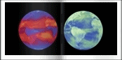 | A View of Heat Given off by The Earth's Surface and Atmosphere and Pumped out Into Space (left) and Sunlight Reflected back Out to Space by the Oceans, Land, Clouds and Aerosols (right) in April 2001. site 'Amateur Astronomy' based upon a view courtesy NASA/Langley and NASA/Goddard |
Climate changes are complex however as they are due to several factors. Climate would certainly fluctuate even without human interaction, due, for example, to how the Sun's activity is varying along small -and large- periods of time, to the various modifications of the Earth's orbit or of its axis tilt or to large scale cycles of the weather elements. The question, if any, is to know what the balance is between such large, slow, natural cycles and the human activity, that is: how significant are greenhouse gases against the backdrop of larger, natural climate changes? Another question is: how "self-correcting"is Earth to possible such changes? That's why most scientists point to that more data are needed, to the effect that a real assessment might be possible of what is really going on. NASA, thus, about in 2006, launched a 10-year data-gathering campaign of operations. Earth's poles generally are believed to be warming faster than the rest of the planet, some 2.6 degrees Fahrenheit faster as summertime changes in clouds are offsetting the low surface albedo at the time and the total warming at the poles is due to changes in clouds, water vapor, surface albedo and atmospheric temperature. Winterial seasonality of the polar warming is largely a result of energy in the atmosphere that is being transported to the poles through large weather systems
The most pessimistic forecasts about the 21st century are that there might occur an average temperature increase of 6° F (3°. C), ecosystems and crops production disruptions, an increase of extreme weather events, a global sea level elevation of about 3 ft (0.9 meter -the global sea level has been found to have risen by 0.1 inch -3 mm- a year since 1993), increased health ill-conditions, diseases prevalence, or freshwater being less availabile. The latest figures, released at NASA in 2006, are stating that the Earth warmed by 0.6° C or 1.08° F over the past 30 years, as it had already warmed by 0.8° C or 1.44° F during the last 100 years. The main part of the excess heat (about 84 percent of it) is absorbed by the mass of the oceans. The temperatures at Earth, unless that, would reach a 49° F (27° C) more! The melting of the whole of the land ice found at Earth, on the other hand, would raise the sea level by 230 ft (70 meters). Any effort to decrease the effects of global warming would however have it having lasting effects at the Earth's poles. Some think that, should the Earth's energetic balance be limited to 0, to equilibrium that is, by 2050, the global warming might be limited to a value of 3,4° F (2° C). If not, the effects might be grave, and in the case of an increase between 7 and 10° F (4-6° C), disastrous, almost as far as the living conditions of rural people worldwide are concerned, with possibly billions of people migrating. That would trigger an extended world war! Some scientists think that, should the greenhouse gases emissions peak by 2015 and are reduced after that date, the temperature rise at Earth would be of 2.9°.C by 2050 (with a peak occurring in 2035, the rise would be of 4°C as a failure to stop any emission would bring to 7.1°.C more)
->Livestock Contributing 18 Percent of the Greehouse Gases!
It looks like livestock worldwide contribute 18 percent of the greenhouse gases, according to the U.N. Food and Agriculture Organization (FAO), a cow, for example, emitting 4 tons of methane a year in burps and flatulence. Some countries are contemplating important taxes on each head of cattle!
It's through the U.N. that the question of the global warming is handled worldwide, in the frame of the so-called 'Kyoto protocol', which had been taken in 1997 and aiming at reducing greenhouse gases. As it's expiring by 2012, a new U.N. conference is to be held in Copenhagen, Denmark, by late 2009
The carbon dioxide, in Earth's natural cycle mainly comes from plant life and geochemical processes on land and in the ocean, which inhale large amounts of it through photosynthesis and then exhale most of it back into the atmosphere. Airborne particles called aerosols are generally causing cooling while greenhouse gas emissions are causing warming. In terms of terminology, 'global warming' refers to surface temperature increases only while 'climate change' includes global warming and any other, supplemental effects that greenhouse gas are generating. As the locution 'global change' never took up, the one 'global climate change' might be the best appropriate due to that changes in precipitation patterns and sea level are likely to have much greater human impact than the rise of temperatures alone
Some people are advocating another stance about global warming, being skeptical about it. They say, for example, that historical documents indicate average temperatures have risen by 1 degree per century since 1400 A.D. as the Earth, in any case, had entered a warmer period since the end of the last Ice Age. Those advocates however are not without any political backthought neither, as they think that the consensual statements about the global warming are a way for the U.S. government to a political tool to increase government control over American lives, incomes and decision-making. U.S. conservatives, on the other hand, are showing that the EPA, the U.S. agency in charge of the global warming might well have prejudiced opinions, and refuse to accept studies which would question the idea that there really is a global warming. Many environmental studies, further, might bear the mark of ill-mediatization, bringing into sensationalism to the public, science facts which are only in development, as further studies usually play down the discoveries announced
->Latest Studies
(by inverted chronological order)
. Latest studies in 2009 are showing a recent cooling trend in the Earth climate. Pro-warming scientists dismiss the find as just a fleeting blip as warming Earth critics say that that cooling wasn't predicted by all the existing computer models, thus that those models are imperfect!
. A most recent 2005 study by the NASA's Goddard Institute for Space Studies is showing like a certitude that the ocean got warmer in average over the past decade. This is matching the computed climate models which predict that the growing amounts of human-produced greenhoused gases are trapping solar radiation and lead to a warming planet. The energy in excess had not been found until now, as it seems well that the decade-long warming of the ocean is accounting for the energy excess. To increase the temperature of the ocean, on the other hand, it taking much more energy than to raise the one of the atmosphere. A definitely warmer ocean means that there really is a global warming. The study thinks that, even with no further increase of the greenhouse gases, the temperature at Earth will rise by 0.6 degrees centigrade (1.1 degrees Fahrenheit)
. A recent study in 2005 thinks that the methane might account for one-third of the man-induced greenhouse effect since 1750! This dramatic increase in proportion of the methane's impact is simply due to that previous studies did not take into account that methane is the main producer of the "tropospheric ozone", this ozone found in the lower strates of the atmosphere. Methane produces ozone by interacting with hydrocarbons, carbon monoxide and nitrogen oxides. Methane, thus, is the main responsible for the "smog". Natural sources of methane range from wetlands to gas hydrates in the ocean floor and permafrost, as fossil fuels, cattle and rice paddies are the main man-related sources
Sea level has risen at an estimated rate of 0.07 inches (2 millimeters) per year during the last 50 years as it seems that in the last 12 years that rate might have increased to 0.12 inches (3 mm) per year. Half of the increase might be attributed to the increase of temperature of the oceans themselves (leading to an expansion of them), as the largest likely factor for the sea level rise might be the increase in the ice melting. The three-fourths of the Earth's freshwater is stored into the glaciers and the polar ice sheets. It's the equivalent of 220 ft (67 m) of sea level which is stored this way! Such ice and water reservoirs might be melting at a much faster pace than thought as over half of the recent sea level rise might be due to the sole melting in Greenland and the West Antarctica Amundsen Sea and glaciers
Some large lakes worldwide, or even large fresh water reservoirs might be hit, in an opposite direction, through the global warming, with, for example, Lake Victoria, in Uganda, having had its water level decrease by 10 ft (3 m) on a span of time of 6 years
Such satellites like Topex/Poseidon and Jason (radar-mapping the ocean's surface, measure of the ocean height and monitoring of the ocean circulation), Ice, Cloud and Land Elevation Satellite (IceSat) (mass of polar ice sheets and their contributions to global sea level change, or Gravity Recovery And Climate Experiment (Grace) (mapping Earth's gravitational field, allowing to better understand movement of water throughout the Earth) are allowing NASA and agency partners like the National Oceanic and Atmospheric Administration (NOAA) and the National Science Foundation (NSF) to explore and understand sea level change via global coverage and the ability to examine the various factors involved in the concept of the sea level rise
Rain precipitation looks like increasing in the tropics and the Arctic Circle with heavier, more punishing storms as semiarid regions might dry up due to a acceleration of the evaporation and precipitation cycle for cause of higher temperatures. More heat over the oceans means more clouds, more precipitation and more flow back from rivers to the ocean
The ozone hole was first detected in 1985. A natural ozone layer is found in the Earth's stratosphere, this layer of our atmosphere lying 11-31 miles (17-50 km) in altitude. The ozone (O3), an unstable form of the oxygen (O2), is the result there of the interaction between the ultraviolet light from the Sun and the oxygen in the atmosphere. Such a stratospheric ozone layer is protecting us from the ultraviolet radiation from the Sun, as this high-energy light causes sunburns and is associated with skin cancers. The ozone layer is lying at 10-25 miles (15-40 km) of altitude. Earth's mid-latitudes are more rich in ozone
Wintertime conditions enable ozone-destroying
chemical processes to occur, and the jet stream prevents a resupply of ozone
from the outside. The ozone layer is destroyed when atmospheric chlorine from human-produced chemicals is turned, inside high polar clouds, by extremely cold temperatures in the stratosphere into forms that destroy ozone. Sunlight also plays a role as such processes occur between 5-31 mi (8-50 km) of altitude. The main destructor of the ozone layer was traced back to chlorofluorocarbons emitted into the atmosphere (chemical reactions occur with chlorine from such human-produced compounds), as various chemicals and local meteorological conditions as well are interacting with the ozone. Chemically reactive, hydrogen-containing, chemical species are too involved in the ozone destruction, due to chemical reactions about 9 to 12-mile (15-20-km) high. Most of the conditions affecting the ozone hole occur above both poles, inside the polar vortex, this band of winds that forms each winter at high latitudes and isolating the polar regions from the mid-latitudes. The vortex is strong and long-lived above the Antarctica, as it's weaker and shorter-lived above the Arctic. The ozone layer, each year, is seen thinning above both Earth's poles, expanding to surrounding areas, possibily exposing populated areas to health harm. The ozone hole varies from 24 to 29 million square kilometers over Antarctica. Winter contributes as an accelerator of the ozone hole, as, for example, the ozone hole over the Antarctic forming since mid-August (their mid-winter there) and lasting until mid-December (their mid-summer). Mild winters, at the northern or southern pole, bring a weaker hole. (it has to be noticed too that a colder stratosphere over the poles bring a larger ozone layer hole). Despite that the chlorofluorocarbons emissions have now been reduced -with the Montreal agreement, since 1987, mostly having eliminated the first generation-chlorofluorocarbons- the ozone layer hole is to persist for at least forty years as the chemicals still persist in the upper atmosphere. There are still considerable uncertainties affecting ozone levels, especially in
the bromine budget and chemical processes of inorganic chlorine. In addition,
stratospheric cooling due to increases in greenhouse gases in the troposphere
may affect the trend and the stability of the ozone layer. Arctic ozone conditions vary more than the seasonal ozone "hole" that forms high
in the stratosphere near the South Pole each winter and spring, and the
temperatures are always warmer than over Antarctica. Exceptionally cold stratospheric
conditions over the Arctic can occasionally lead to substantial ozone depletion like by late winter 2010 and early spring 2011. Ozone losses occur
over the northern polar regions when temperatures drop below -108 degrees F (-78 degrees C), when clouds form in the stratosphere
->The Ozone Layer's Decline Halted, Albeit the Recovery Will Take Longer Than Planned!
Although the ozone hole over Antarctica is remaining opened wide, the ozone layer worldwide was found in May 2006 to have halted its decline. The ozone in the upper stratosphere (above 11 miles -18 km) was found recovered mostly due to the ban of the CFCs, those ozone-destroying gases as in the lower stratosphere (between 6.2 and 11 miles -10 and 18 km), ozone was found to recover much better -as the causes of the recovery there remain unclear. The northern ozone layer however will not be restored to its 1980 levels before about 2068 -or about mid-century, as some experts state between 2030 and 2040. Data are unavailable about the Antarctic hole. The ozone hole, generally, will not be seen shrinking significantly before 2018
The effects of the ozone hole, North, seem to be attenuated, some years, as specific weather conditions -namely stratospheric winds- are bringing ozone from mid-latitudes up to the poles, filling the gap. Strong solar storms however, on the other hand, may affect the ozone layer in the other direction, bringing for example a modification in the activity of the Arctic stratospheric polar vortex. Energetic solar particles are triggering chemical reactions which, in turn, yield nitrogen gases at at least 6 mi (10 km) above the stratosphere. Such gases, like the nitrogen oxide and nitrogen dioxide, together destroy the ozone layer (nitrogen trioxide (NO3) virtually disappears from the atmosphere when Sun rises). They are drawn down more quickly than usual by the Arctic's polar vortex upper winds. The main accelerator of the ozone hole remains the increase of carbon dioxide levels anyway, which are bringing a cooler stratosphere. High altitude clouds, at last, which, like the cirrus, cirrostratus, and cirrocumulus, may be found at the lower part of the ozone layer, are related to the ozone destruction too, as Polar stratospheric clouds (PSCs) -these high polar clouds forming when stratospheric temperatures drop below -108°F (-78°C)- and aerosols as well are acting like a medium or host to create ozone-destroying chemicals. Chemical reactions on the surfaces of these clouds activate chlorine, converting it into forms that destroy ozone when exposed to sunlight. The Arctic’s ozone depletion generally tends to be milder and shorter-lived than the Antarctic’s because the three key ingredients needed for ozone-destroying chemical reactions —chlorine from man-made chlorofluorocarbons (CFCs), frigid temperatures and sunlight— are not usually present in the Arctic at the same time. The majority of ozone depletion in the Arctic happens inside the so-called polar vortex: a region of fast-blowing circular winds that intensify in the fall and isolate the air mass within the vortex, keeping it very cold. The ozone hole there depends upon the vortex' conditions as the vortex further may lock the Arctic's ozone which mostly is transported from the tropics. In comparison, the Antarctic vortex is very stable and lasts until the middle of spring
A source of ozone, at last, in the lower atmosphere, is due to carbon monoxide like that emitted by cars. Incomplete combustion can generate ozone. Such a low-lying ozone has a relatively long lifetime in the atmosphere and hence is often used for identifying human-induced pollution. By 2013, a study found that high-latitude regions such as Europe had a smaller impact on prejudices to the ozone layer than lower-latitude regions like North America. Ozone was observed to be a more efficient greenhouse gas over hot regions like the tropics or relatively cloud-free regions like the Middle East
Most Basic El Niño
El Niño, Spanish for "the little boy," is the oceanic component of a climate
pattern called the El Niño-Southern Oscillation, which appears in the tropical
Pacific Ocean on average every three to five years. The most dominant
year-to-year fluctuating pattern in Earth's climate system, El Niños have a
powerful impact on the ocean and atmosphere, as well as important socioeconomic
consequences. They can influence global weather patterns and the occurrence and
frequency of hurricanes, droughts and floods; and can even raise or lower global
temperatures by as much as 0.2 degrees Celsius (0.4 degrees Fahrenheit).
During a "classic" El Niño episode, the normally strong easterly trade winds in
the tropical eastern Pacific weaken. That weakening suppresses the normal upward
movement of cold subsurface waters and allows warm surface water from the
central Pacific to shift toward the Americas. In these situations, unusually
warm surface water occupies much of the tropical Pacific, with the maximum ocean
warming remaining in the eastern-equatorial Pacific. The reverse is true under the name of La Niña. A La Niña often follow an El Niño episode and is essentially the
opposite of it. During a La Niña episode, trade winds are
stronger than normal, and the cold water that normally exists along the coast of
South America extends to the central equatorial Pacific. La Niña episodes change
global weather patterns and are associated with less moisture in the air over
cooler ocean waters, resulting in less rain along the coasts of North and South
America and the equator, and more rain in the far Western Pacific. A unusual 'coastal' El Niño climate pattern has warm water to pool off the coast of southern Ecuador and northern Peru, with rain falling in
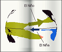 | A Illustration of El Niño and El Niña. site 'Amateur Astronomy' |
El Niño and El Niña are two alternate phases of a global climate cycle in the Equatorial Pacific ocean. This cycle is called the Niño-Southern Oscillation (ENSO) and is a type of disruption of the Pacific ocean weather pattern. Normal climate conditions along the equatorial Pacific Ocean are warm water in the Western Pacific and a westwards cold tongue in the Eastern Pacific starting at the northwestern South America. During an El Niño episode the western warm water extends along the equator up to the California and the Central America coasts. During an El Niña episode it's the cold tongue which extends westwards rendering the equatorial Eastern Pacific cooler than usual. An El Niño means a warm equatorial Pacific, an El Niña means a cold equatorial Pacific. Warm waters in the Western Pacific are due to trade winds which are blowing West. They are piling up warm surface water on the other side of the Pacific as, on the other hand, cold, nutrient-rich, water is rising from deeper levels to the surface, off the coasts of South America. The Niño-Southern Oscillation (ENSO) is due to a modification of the trade winds in the Pacific. Easterly trade winds are weakening letting room for westerly ones, which form the so-called 'Kelvin wave'. Neutral conditions are extent between an El Niño and and El Niña. Sea-surface, and below-surface temperatures warming in the concerned zones precede the apparition of an El Niño as it changes the wind patterns of the Pacific. In term of local weather each side of the Pacific, an El Niño phenomenon brings rainfalls and flooding in Peru, more rainfalls in the southeastern United States and California, and warmer winters in the northwestern USA. The El Niño brings drought in Indonesia, Australia, the Philippines, and the northeastern Amazon basin as there is a decrease of the hurricanes in southeastern USA (with an increase of them in the Eastern Pacific). A El Niño brings too more rainfall on the eastern and central-eastern Pacific. An El Niña episode brings colder temperatures and a stormy weather in northwestern USA, drier than usual conditions in the southeastern USA and California as a colder Pacific is less prone to evaporation as West-East jet streams bring very little precipitation thus and are deviated northwards, flowing near the border between the USA and Canada. The El Niña brings excessive rains in Indonesia and northeastern Amazon basin as it can contribute too to stronger jet streams over Northern America. Generally, during an El Niño, a rainfall pattern is seen stretching from the northwestern coasts of South America up to the East of New Guinea as during an El Niña, this pattern is shifted West, that is that it stretches from the Pacific Ocean's center up to Borneo, Indonesia and the Philippines. A El Niña is bringing more rain in the far Western Pacific as less rain along the coasts of North and South America and along the equator. Most recent studies, in 2008, leads to think that the impact of the ENSO patterns unto the US climate are much higher than thought. In-between conditions between two cycles can bring with them a high degree of uncertainty, bringing about 'normal' weather conditions or often delivering unruly jet stream patterns and wild weather swings
El Niño and El Niña however may be overtaken by the so-called 'Pacific Decadal Oscillation' (PDO) a pattern of alternating two phases, usually about 20 to 30 years. The PDO is detected as warm or cool surface waters in the Pacific Ocean, North of 20° N. During a "warm", or "positive", phase, the west Pacific becomes cool and a warm horseshoe pattern of waters, running North, East, and South, surrounds it; during a "cool" or "negative" phase, the opposite pattern occurs
->Why Such a Mediatization of El Niño As Other Such Oscillations Not? The stress on the El Niño phenomenon might not be innocent as such a mediatization is not as strong for other such similar climate patterns in other parts of the world, or in the Pacific Ocean self. A similar pattern to El Niño, for example, is known for the North Atlantic Ocean as it's far less mediatized. The 'North Atlantic oscillation' (NAO) is a fluctuation of the difference of pressure between the Icelandic Low and the Azores high, those permanent zones of lows and highs which control the strength of the westerlies across the North Atlantic towards Europe. The NAO was discovered in the 1920s, with a positive NAO occurring with the difference between the lows and highs large and a negative NAO the difference small. A large difference is increasing the westerlies, bringing cool summers and mild and wet winters in Europe. A small difference suppresses the westerlies, leading to cold winters, as storms are tracking southwards down to the Mediterranean Sea, bringing rainfall there. The NAO is particularly efficient between November and April each year, as it seems to be of consequence too about the eastern part of Northern America: with a strong NAO a southwesterly circulation prevents the Arctic air from descending over the continent and may combine to El Niño
The 'Arctic oscillation' (AO) highly correlates the NAO, as the Arctic oscillation is a pattern of higher-lower of sea-level pressures between the polar and the mid-northern latitudes. A negative AO has a pressure higher than normal over the polar regions and lower than normal at about 45 degrees North and the reverse with a positive AO, which further brings storms North over Scotland and Scandinavia, and to Alaska, as conditions are dry over California, Spain, and the Middle East. Most scientists agree on that the AO to be the cause for much of the changes in the Arctic. More oscillations still are involved over other regions and oceans of the world
The Pacific Ocean is now in a cold phase of the Pacific Decadal Oscillation (PCO), a pattern of climate variability every 5 to 20 years, associated with a general cooling of the waters there. During such a cool phase, a contrast exists between a horseshoe pattern of higher than average, warm waters, connecting North, West and South of the ocean, as a cool wedge of cold waters reaches from the Americas into the eastern equatorial Pacific. These warm and cold regions are reversed when the Pacific is in a warm phase of the PCO (like it was in the 1980s and 1990s). The PCO can induce La Niãna impacts around the basin, like shifts in marine ecosystems, land temperature and rainfall patterns. The PCO of course is in an interaction, as far as its consequences are concerned, with the El Ninõ-La Ninã
Such precisions bring to say that, at least, better models are needed to a comprehensive view of such a complexity!
Last El Niño episodes occurred in 1986-1987, 1991-1992, 1993, 1994, and 1997-1998. Usually El Niños may not occur at such a frequency as between 1990 and 1994 but along a periodicity of roughly 4 to 12 years relative to the neutral state of the Pacific weather system. A strong El Niña occurred in 1988-1989, a weaker one in 1995-1996. El Niñas do not necessarily follow an El Niño. The warm water event off the coasts of South America was first recognized by a fisherman around Christmas, hence the name "El Niño" which is the name for the Christ child in Spanish. El Niño is impacting too the Pacific Ocean jet stream winds and leads to weather changes in various parts of the world. A relatively new type of El Niño, which has its warmest waters in the central-equatorial Pacific Ocean, rather than in the eastern-equatorial Pacific, is becoming more common and progressively stronger as studies showed by 2010 as the El Niños have doubled in intensity since 1982 inducing a long-term warming trend seen in the central Pacific. Climate change, that study says, may already be affecting El Niño by shifting the center of action from the eastern to the central Pacific a El Niño's impact on global weather patterns is different if ocean warming occurs primarily in the central Pacific, instead of the eastern Pacific. Such a El Niño is called the "warm-pool El Niño," "dateline El Niño" or "El Niño Modoki" (Japanese for "similar but different"). Such central Pacific El Niño events were observed in 1991-92, 1994-95, 2002-03, 2004-05 and 2009-10. A recent study found many climate models predict such events will become much more frequent under projected global warming scenarios
The La Niña episodes, on the other hand, are bringing that the "marine desert" of the Pacific Ocean, that is the equatorial zone there, is blooming during about one month with phytoplankton. It seems like that an El Niño episode, at the opposite, is accentuating the void in plankton in the equatorial Pacific. These effects of the El Niño/La Niña events on the phytoplankton is likely due to that iron, the fuel for the phytoplankton, in the central Pacific is weak, as such regions are remote from any land, where sediments and dust are sources of iron. Another source of iron is found in some regions of the ocean, like off coast South America, where deeper ocean waters are upwelling, and bringing nutrient to the ocean's surface to replace the surface waters which are blown away West when the winds regime is normal. In case of an El Niño event, such easterly winds cease and the upwelling too. Such concentrations of plankton are of importance too as when such plants die, they are sinking down to the bottom of the ocean, increasing the amount of carbon, there and leading to a possible lack of viable conditions for the other plants and organisms
The climate oscillation in the Pacific Ocean has wider effects, forcing changes in weather in regions far away from the Pacific ocean. On another hand it seems that the El Niño/Niña phenomenons are linked to a large oceanic currents system which is named the "Great Ocean Conveyor". The Great Ocean Conveyor is a larger Gulf Stream of sort. It's working on a 15-20 year cycle and it is transporting warm water from the Pacific Ocean into the Atlantic Ocean through the Indian one. When the conveyor is active, the Atlantic Ocean climate is warmer and wetter as the Pacific Ocean one is colder and dryer (that is that El Niño phenomenon). And the reverse (El Niña in the Pacific Ocean) when the conveyor is inactive. We should now have entered an active phase since about 1995. The Great Ocean Conveyor does not seem to be concerned by Arctic ice thawing in its Pacific Ocean part. Waters there are just cold water rising to surface, and where the phenomenon takes place is far South Bering Strait. Nor is it by a possible Antarctic thawing neither, as the cold, eastwards, part of the conveyor there is underwater only, along the Antarctic coasts. The vertical exchange of water, in the Conveyor Belt, between surface and abyss in the northern North Atlantic and the high southern latitudes is a important determinant of the vigour of the circulation
Different stories seems to unfold at the Earth's two poles. In the Arctic, more than half of the summer sea ice might have disappeared since the late 1970's as meanwhile, in Antarctic waters, sea-ice cover has been stable, and even increasing, for decades, apart a historic low by local fall 2017. Todays regions considered like loosing the more quickly their ice coverare Greenland, where the massive Ilulissat Glacier is depositing 35 to 50 cubic kilometers of icebergs into the ocean each year, raising sea level, the Arctic, where sea ice continues to decline in both area and volume, and Antarctica, where massive ice shelves the size of some small U.S. states have collapsed in recent years
->A late, February 2006, NASA-funded study, using the atmosphere-ocean coupled climate computer model known as "GISS Model E-R", has been showing that the last massive climate change which occurred 8200 years ago due to a large flood of freshwater in Northern America did not modify that much the Earth's climate. Such a flood was due to retreating glaciers opening a route for two ancient meltwater lakes, known as Agassiz and Ojibway, to suddenly and catastrophically drain from the middle of the North American continent. This took place after the end of the last Ice age, that is as our current, warm period had begun. The flood was equivalent to 25 to 50 times the flow of the Amazon river as it's in North Atlantic and Greenland that temperatures showed the largest decrease, with slightly less cooling over parts of North America and Europe. The rest of the northern hemisphere showed very little effect however as temperatures in the southern hemisphere remained largely unchanged. It's the ocean circulation which seems to have been most hit as it initially dropped by half after the flood, taking 50 to 150 years to rebound. Such a study is of importance as the current melting of the ice sheets at Earth's both poles might be of a less quantity than the flood 8200 years ago. Should such studies prove true, this might be the indice that the current climate change might be mostly natural, on one hand, and mostly of a low level and impact, on the other hand
In terms of types of the Arctic ice, the thicker ice, known as multi-year ice, survives through the cyclical summer melt season, when young ice that has formed over winter just quickly melts again. The rapid disappearance of older, perennial ice would make Arctic sea ice even more vulnerable to further decline in the summer. A periodic nine-year cycle would have the sea ice extent first grow for a few years, and then shrink until the cycle started again. This cycle is reminiscent of one occurring on the opposite pole, known as the Antarctic Circumpolar Wave, which has been related to the El Niño-Southern Oscillation atmospheric pattern. If the nine-year Arctic cycle were to be confirmed, it might explain the recoveries periods observed of the sea ice cover. For the third year in a row the Arctic perennial sea ice has been found disappearing at about 13 percent a year relative to the average in 2004. As the Arctic ice cover have been monitored since 1978, it was found melting at the important rate of 9 percent per decade. It should have disappeared by 2070! The period between early spring and late fall -that is when the ice is melting- is getting longer over the years as the Arctic regions are warming at the impressive rate of 2.5° C per decade. Its off coast of Northern Alaska, in the Baffin Strait, and on a line running from Iceland to the New Zemble that the increase is the largest. Northern part of North America and Scandinavia are also affected as the Russian coasts of the Artic are safe. This modification of Arctic conditions might be related to global warming as well as to variations in climate patterns in the region. The thinning of the Arctic ice cover might be the real translation of the burning of fossil fuels or it might be due to changes in air pressure and wind patterns over the pole. The ice cover -what is called the perennial sea ice- should recover during winter time, but it's not the case. This loss of the Arctic ice may affect the climate as the albedo of ocean versus ice's allows more heat still to be stored in the region. Most pessimistic views state that Arctic summer ice might be reduced to the half of its thickness during the 21st century, and that further developments might bring a 3 ft (one-meter) surge of seas -Greenland ice melting included, and a disruption of the Gulf Stream mechanism. According to these views, the additional average temperature increase would be of 3-5° degrees over land and up to 7° over the Arctic as the increase is estimated to have been 4° over the last 50 years. As far as Greenland is concerned, data are showing that a steadily thinning of the ice sheet is seen at elevations of under 1,200 ft (2,000 meters) only. Ice cover in the higher elevations of central Greenland stay mostly in balance. On the other hand some thickening has been observed lately in lower locations of southeastern Greenland due to unusual heavy snowfalls (warm air has more capability to retain moisture, hence to produce precipitation). There like elsewhere, scientists warn that data on a longer period of time are required for definite conclusions as a late study, which re-assesses the ice loss through the glaciers calving over the last ten years 1996-2005, is showing that the total Greenland ice loss doubled during the period. A better knowledge of how much water ice might be melting in case of a global warming might be expected, as scientists are to drill deep into the Greenland ice layers to study layers which are between 130,000 and 115,000 years old, which was the last warm age on the Earth, with temperatures similar to the rise expected in case of a global warming. Reductions in Arctic sea ice may be intensifying the chemical release of bromine into the atmosphere on the other hand, resulting in ground-level ozone depletion and the deposit of toxic mercury in the Arctic, as determined by the interaction between the salt in sea ice, frigid temperatures and sunlight. When these mix, the salty ice releases bromine into the air and starts a cascade of chemical reactions called a 'bromine explosion.' These reactions rapidly create more molecules of bromine monoxide in the atmosphere. Bromine then reacts with a gaseous form of mercury, turning it into a pollutant that falls to Earth's surface
As far as the Antarctica is concerned, it mostly cooled during the last 30 years but is expected to warm during the next 50. The cooler episode, lasting since the late 1960s, was due to depleted ozone levels and greenhouse gases. Such elements are contributing to a typical atmospheric climate pattern called the Southern Annular Mode (SAM). A positive phase of the SAM is trapping colder air above the Antarctic due to stratospheric and tropospheric westerly winds circling around the Antarctica. A recovery of the ozone level in the coming decades might paradoxically promote a negative phase of the SAM leading to a warming. A higher ozone level would reject much more ultraviolet radiation. Such a change could obviously become a threat if ice sheets there melt and slide into the ocean, raising greatly the global sea levels. Ice sheets as big as Rhode Island have already collapsed into the ocean from the Antarctic Peninsula as the westerly, warmer, winds existing at 60-65° of latitude South are reaching this part of the South Pole. The same climate oscillation pattern is seen above the Arctic and known as the Arctic Oscillation or the Northern Annular Mode (NAM). By 2012 scientists found that warm ocean currents attacking the underside of Antarctic ice shelves are the dominant cause of recent ice loss there, most of those found in West Antarctica where inland glaciers are flowing down to the coast and feeding these ice shelves. Winds are also a factor as they affect the strength and direction of ocean currents. A different picture is seen on the Antarctic Peninsula, the long stretch of land pointing towards South America as the study found thinning of the largest ice shelf on the peninsula can be explained by warm summer winds directly melting the snow on the ice shelf surfaces
The melt of the West Antarctic Ice Sheet (or WAIS) would mean, globally, a sea rise of 16 ft (5 meters) globally. Varied factors however might make the rise larger in some regions than in others, like the gravity pull the WAIS exerts on the surrounding oceans, the rebound of the underlying bedrock, or the Earth's axis being shifted by 1,600 ft (500 m) from its current location. This, in that order, would lead to higher sea levels in the northern hemisphere (and a decrease within a 1,200 miles (2,000 km) radius from the Antarctic, further increase the sea level rise, and shift water from the southern Atlantic and Pacific towards North America and the southern Indian Ocean. Those effects would thus mitigate the effects, global, on the sea rise, leading to some 20-23 ft (6-7 meteres) in some areas, like southern Florida and Louisiana, and even Washington D.C. The U.S. West Coast, Europe and aeras around the Indian Ocean would be more at risk too. Such studies, thus, are showing that, should any sea level rise occur from the melting of the West Antarctic ice sheet, that rise might well be larger than previously thought for some areas in the world. More temperate studies are too stating that the melting of West Antarctica might be accelerating lately due to the melting of the floating ice shelf which until now was preventing the glaciers of the region to slip into the sea. Instead of a raise in sea level by 30 to 50 inches (0.7 to 1.3 meters) for the 21st century, that would mean some 3 to 5 ft (1 to 1.5 meters) instead! The ocean surrounding Antarctica further seems to have warmed about 0.36 degrees Fahrenheit (0.2° C) in the past decade, which is the double of the average warming of all the oceans of Earth over the last 30 years. The melt of the West Antarctica continental shelf is added, in any way, with surface winds which, when strong, stir the Southern Ocean and lift the warm water onto the shores. Along the Antarctic Peninsula, on the other hand, a spine of mountains forces passing winds to give up their moisture as snow and feeding glaciers there. Latest studies are showing that the defining characteristic of West Antarctica is that the majority of the ice sheet is grounded on a bed that lies below sea level, making the sheet unstable. That could take several centuries so the effect of the melt about global sea level occur, in the order of 1 foot to about 3 feet (26 to 98 centimeters)
The East of Antarctica too, would be subject to the induced effects of glaciers not being contained anymore by a melting ice shelf
->A Ozone Hole Curing Could Make the Antactic Warmer!
A study early 2009, is showing that the improvement in the health of the ozone hole over Antactica could unluckily lead to that the eastern part of the continent could get into the global warming in turn. That innermost part of the Antarctica, until now, had been safeguarded from warming and melting due to that the thinning of the ozone layer above had reinforced the circumpolar vortex -a set of winds and weather currents isolating the continent from the warmer air around. The study shows however that it's still western Antarctica which -taking the new study or not- is still the most prone place there to warm and melt
How much of the overturning circulation is driven by the winds and how much by the formation of cold, dense water that sinks into the deep sea is still unknown in terms of oceanic currents. North Atlantic weather patterns are ruled by an ocean circulation system. Warm waters coming from tropics are yielding a mild climate along western Europe and Labrador coasts. Such a pattern is better known under the name of "Gulf Stream", starting off the southeastern coast of the USA. Further studies showed that this current pattern has an underwater part, starting about Labrador and bringing cold water back to tropics. Late alarming reports are stating that the North Atlantic currents modification would be a consequence of the melting of the perennial Arctic ice as they would bring doomsday next day and abrupt climate changes on the shores of the Atlantic Ocean. An addition of fresh water either directly, either under the form of increased precipitations in the region, would render waters more buoyant. Such a buoyant water would not sink anymore, hindering the Gulf Stream process. A thorough scientific study of the North Atlantic Ocean circulation system's part which is dubbed the "sub polar gyre" is showing that this current weakened considerably in the late 1990s compared to the 1970s and 1980s however. Sub polar gyre belongs to the Gulf Stream system. It is moving water in a counterclockwise pattern from Ireland to Labrador. Once there waters are plunging downwards, heading back slowly to equator as an intermediate depth current. Such a journey may take about 20 years. Sub polar gyre is sensitive to local weather conditions and particularly to perennial ice Arctic melting. A modification of this current might bring a change to North Atlantic climate system and perhaps to global climate. Waters in the 1990s have been found warmer about Labrador, decreasing contrast with warmer southern latitudes waters, hence reducing the driving force behind ocean circulation. Until now a sub polar gyre weakening had already be observed but was linked to oscillations of a large-scale atmospheric pressure system known as the North Atlantic Oscillation (NAO), and considered normal. This study is showing that current weakening continued despite the fact that NAO switched twice in the 1990s. Sub polar gyre might have an evolution of its own. A recent position, further, is that the NAO might generate a lull of some 30 years of the global warming as it might be currently the dominant cause among the ones governing the Earth's climate. The proponents of the global warming are even obliged to agree that the NAO might have been responsible of the increase in temperatures of those last 30 years. Scientists are stressing that they need a further 5 to 10 years to definitively assess what is going on, that is whether the current weakening is part of a natural cycle or is resulting of factors related to global warming
->Another Natural Cycle Discovered in the Arctic!
An oceanic current called the 'Arctic Ocean circulation' is now back to clockwise -like it was before 1990, as, since the 1990s, it had passed to counterclockwise. That change might be linked to the weakening of the 'Arctic Oscillation', a large scale atmospheric feature of the region, which reduced the salinity of the water there and induced the circulation change. There too, that discovery is showing how, on lengths of time of 10 years, changes are due to natural cycles and not the global warming. The thinning of the Arctic ice of those recent years might be due too to the process. The Arctic Oscillation was stable until 1970, then varied according to decadal rythmes, as it eventually stabilized in the 1990s. It now tends, itself too, to accentuate a trend to counterclockwise
Recentest measurements of the 'Atlantic Meridional Overturning Circulation', which is part of the global ocean conveyor belt show no significant slowing over the past 15 years. The 'Great Ocean Conveyor' is a larger Gulf Stream of sort. It's working on a 15-20 year cycle and it is transporting warm water from the Pacific Ocean into the Atlantic Ocean through the Indian one. When the conveyor is active, the Atlantic Ocean climate is warmer and wetter as the Pacific Ocean one is colder and dryer (that is that El Niño phenomenon), and conversely. A key part of the Conveyor's Belt might be a powerful and swift current discovered in 2010 under the Antarctica. That current is conveying very cold and salty water from there to further North around the Kerguelen Plateau whence it's branching out. The data suggest at the opposite the circulation may have even sped up slightly in the recent past. The Atlantic overturning circulation proper is a system of currents, including the Gulf Stream, that bring warm surface waters from the tropics northward into the North Atlantic. There, in the seas surrounding Greenland, the water cools, sinks to great depths and changes direction. What was once warm surface water heading north turns into cold deep water going south. This overturning is one part of the vast conveyor belt of ocean currents that move heat around the globe. Without the heat carried by this circulation system, the climate around the North Atlantic -- in Europe, North America and North Africa -- would likely be much colder. Scientists hypothesize that rapid cooling 12,000 years ago at the end of the last ice age was triggered when freshwater from melting glaciers altered the ocean's salinity and slowed the overturning rate. That reduced the amount of heat carried northward as a result. The circulation seems to have sped up about 20 percent from 1993 to 2009. The latest climate models predict the overturning circulation will slow down as greenhouse gases warm the planet and melting ice adds freshwater to the ocean. Warm, freshwater is lighter and sinks less readily than cold, salty water. For now, however, there are no signs of a slowdown in the circulation. as the changes observed or conjectured are probably part of a natural cycle, likely matching a decades-long natural pattern of Atlantic heating and cooling. If or when the overturning circulation slows, the results are unlikely to be dramatic. Today's warmer conditions suggest that a slowdown would have a much smaller impact now than 12,000 years ago. Some have suggested cyclic changes in the overturning may be warming and cooling the whole North Atlantic over the course of several decades and affecting rainfall patterns across the United States and Africa, and even the number of hurricanes in the Atlantic. A study by early 2012 has shown that melting Arctic sea ice does not release freshwater enough to have an impact on the global 'ocean conveyor belt' that redistributes heat around our planet as a freshwater source lies within another cause. Northern Hemisphere's West-to-East atmospheric circulation, known as the 'Arctic Oscillation' which strength is increasing, is indeed triggering a eastward shift in the path of Russian runoff through the Arctic Ocean through resulting counterclockwise winds. Freshwater from Russian rivers is driven away from the Arctic's Eurasian Basin, between Russia and Greenland, to the Beaufort Sea in the Canada Basin. The stronger Arctic Oscillation is associated with two decades of reduced atmospheric pressure over the Russian side of the Arctic. Freshwater protects sea ice by helping create a strongly stratified cold layer between the ice and warmer, saltier water below that comes into the Arctic from the Atlantic Ocean. Arctic Ocean salinity is similar to what it was in the past, but the Eurasian Basin has become more saline, and the Canada Basin has freshened the most since 50 years. The Beaufort Sea stores more freshwater when an atmospheric pressure system called the 'Beaufort High' strengthens, driving a counterclockwise wind pattern
The Indian "brown cloud" is a thick cloud of sooth and ozone pollutants which is generated over India and trapped along the Himalayan Range, over the Gange, by the summer monsoon, these earthward winds. This cloud of pollutants is generated by agricultural fires, home heating, and industrial and vehicle emissions. In winter the cloud is transported over the Bay of Bengal by the reversed monsoon, with seaward winds. On the other hand at the same season, farmers in Southeast Asia are performing agricultural burnings, as Chinese people are burning more energy to fight the cold of winter. All this leads to that a large belt of pollution forms, spreading both sides of the region, in the Pacific Ocean on one hand, and towards Africa on the other. Moreover, this season is the season too when African farmers are performing their own agricultural burnings. This eventually, each winter, contributes to a vast zone of pollutants stretching from China to West Africa! A well-known consequence of it is the high concentration of pollutant, low-lying ozone over the South Atlantic Ocean. The 'brown cloud' proper, in Asia, on the other hand, is contributing, by 50 percent, to the melting of the Himalayan glaciers, leading to a threat to the region water sourcesPollution, on the other hand, is a global problem, with pollution yielded in one part of the world maybe travelling to other parts. Like an example, pollution from East Asia is finally found over western North America, where it represents up to 15 percent of the pollution there, with the largest load in spring, and least in summer. Studies in 2010 have shown that the Asian monsoon, by spring, is spreading the pollution from China and India, or Indonesia around the world as it lofts it high, up into the stratosphere. It brings there pollutants such as black carbon, sulphur dioxide and nitrogen oxides up to about 20 to 25 miles high. Strong stratospheric winds completes the work spreading the pollutants around the planet where they can linger for years before falling back Earth or breaking down. That could also affect the ozone layer and create a cooling, or a warming layer
In India itself, before monsoon season begins, the winds over the Indian subcontinent shift, blowing inland instead of out to sea, and carry immense amounts of dust from Africa and the Arabian Peninsula to India, degrading the air quality further. During monsoon season, rains wash some of the dust and soot from the air, but other human-produced pollutants continue to build up. After monsoon season, dust transport is reduced, but human-produced pollutant levels skyrocket, as biomass burning and the use of diesel-fueled transportation soar. During winter, seaward-blowing breezes disperse all the pollutants across the subcontinent and out to sea, where they remain until the pre-monsoon winds blow again
Fires concerning living and dead vegetation currently is called 'biomass burning' as it includes human-induced burning as well as naturally occurring wildfires. Biomass burning happens most in boreal forests in Alaska, Canada, Russia, China, Scandinavia, savannah grasslands in Africa, tropical forests in Brazil, Indonesia, Colombia, Ivory Coast, Thailand, Laos, Nigeria, Phillipines, Burma, Peru, temperate forests in U.S., Europe and agricultural waste after harvests in U.S., Europe. 90 percent of biomass burning is human instigated. Biomass burning accounts for the annual production of some 30 percent of atmospheric carbon dioxide, a leading cause of global warming. Flaming combustion like the kind in thin, small, dry grasses in savannahs results in near-complete combustion and produces mostly carbon dioxide. Smoldering combustion in moist, larger fuels like those in forest and peatlands results in incomplete combustion and dirtier emission products such as carbon monoxide. Boreal fires burn the hottest and contribute more pollutants per unit area burned
Website Manager: G. Guichard, site 'Amateur Astronomy,' http://stars5.6te.net. Page Editor: G. Guichard. last edited: 8/2/2016. contact us at ggwebsites@outlook.com