| CONTENT - What hurricanes are and how they work. A tutorial in our series about the Earth |
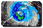 |
Hurricane Ophelia on Sept. 14, 2005. picture Naval Research Laboratory, Marine Meteorology Division |
Hurricanes are well known to USA southeastern coasts dwellers. Hurricanes are appearing in summer and fall in the tropical zone of the North Atlantic Ocean. Warm waters there are having moist air rising and transforming into clouds. Pressure differences are then adding winds leading to loose clusters of showers and thunderstorms. Weather and persisting water heat make such features turn into hurricanes, those vast zone of spiralling clouds and winds, or a tropical wave, with moist air rised in the low air-pressure area replaced by surrounding air, which forms circulation. Clouds and winds are spiralling inwards, toward the "eye" of the hurricane. Winds and storms are most violent just around this center, in the "eye wall" as the eye proper has just calm winds and clear skies. Storm-cells called 'hot towers' as tall as 10.5 miles (17 km) have been spotted both over land and sea on the side of the eyewall as they may warm the air in the eye of the cyclon and thus intensify winds there throught a process termed 'forced subsidence'
Hurricanes may be about 60 mi (100 km) wide as gale winds and heavy rains are seen up to 120 mi (200 km) from the hurricane center. The eye varies between 10 mi (16 km) and 30 mi (48 km). The stronger the hurricane, the smaller the eye. Just in the hurricane's eye, the air, coming from up to the lower stratosphere, is sinking down, as in the ring of strong thunderstorms around it, it's strongly hurled upwards. Hurricanes may last from days to about one month. As better monitoring, prediction, and preparedness plans are lowering the direct effects of hurricanes, indirect damages are still important, under the form of landslides and floods which may cause thousands deaths, or due to an increase in coastal populations and properties values. Hurricane Andrew e.g. caused $ 26.5 billion in damages in Miami, Fla. metropolitan area
As hurricanes take their source in the warm waters in the tropical Atlantic between Africa and the Lesser Antilles, pre-existing disturbance near Africa, a low-pressure system for example are a factor too. Such a tropical weakness moves out into the warm waters out in the ocean and powers up. Neutral wind conditions are adding too, which, for the Atlantic hurricanes, means that they are related to a El Niña phenomenon and not a El Niño, with the latter featuring strong winds, which are dispersing tropical waves in the air layers and scattering and drying the heated air. Once pushed westwards by trade winds, hurricanes are naturally taking a polewards path. This leads them directly on USA southeastern coasts. From there, due to their water heat-engine fading, their move North, remaining dangerous, and eventually turn into usual North Atlantic cyclones. Hurricanes may too hit more North in the USA, albeit more rarely -about each 12 to 17 years (?). More North may be as North as the Maine, with winds of about 72 mph (116 km/h). Extra-tropical cyclones -which are those occurring or found outside the tropics- tend to be significantly larger. In North America, they most usually occur during winter as such winter storms are local and due to a difference in temperatures over a northwestern cold, and southeastern warm area. Extra-tropical cyclones may also tap power from the jet stream which ferries air from West to East. A hybrid hurricane like like hurricane Sandy in October 2012 on a other hand can feature both a warm core from tropical origine and its power from the extra-tropical origin. Hurricanes generally tend to drift northward because of the forces acting on the fast swirls of wind as the planet rotates
In the western part of the Pacific Ocean such weather events are known like "typhoons" as elsewhere they are termed "tropical cyclones". "Tropical cyclones" on the other hand is the generic name for any of such meteorological events; an hurricane is a tropical cyclone. All such events are working in the same way
Once the process started, a gradation of weather may occur before turning into a real tropical cyclone. An organized circle of winds and thunderstorms around a center is called a "tropical depression". It's the first stage. If winds there eventually reach 39 mph (63 km/h) or more, the storm turns into a "tropical storm". At last, if the winds reach 74 mph (119 km/h) the tropical storm turns into a tropical cyclone, that is a hurricane -or a typhoon. Names are attributed to these events starting at tropical storms. The official Atlantic hurricane season runs from June 1 through November 30 as the one of typhoons in Asia could begin as soon as by early April, and generally from June to November, or the season of rains and monsoon, a one relatively cooler than the dry season. In the Atlantic area, the majority of hurricanes and major hurricanes form in the second halve of the season. 6 to 7.5 hurricanes are seen there along this period each year, along with about 9-10 tropical storms. 1.5 to 3.8 hurricanes may be qualified major ones as, generally, 5 hurricanes are reaching the U.S. coastline on a three-year timespan. On the other hand, a below-normal hurricane season in the Eastern and Central Pacific has see six to eight hurricanes only, instead of 20, with two to four of them becoming major storms. The Eastern Pacific hurricane season, as far as it is concerned, usually runs from May 15 to Nov. 30, with a busiest July-September as in the southern hemisphere generally, cyclones's season spans from late October to May
The Saffir-Simpson hurricane scale comprises 5 degrees with winds ranging from 74-95 to over 155 mph. Hurricanes in USA are affecting the Atlantic and Gulf coastal zones, as inland areas may be affected by correlative weather such as high winds, tornadoes or floods. Japan is a good target too for local hurricanes -called "typhoons"- with an average of more than a dozen each year! A typhoon by early 2011 in northeastern Australia reached a strongest since 1918, with winds gusting up to 186 mph. From one end to the other that storm, named Yasi, was found to be 901 miles (1450 km) as its highest thunderstorms reached a incredible 11.9 miles of altitude (19,200 km)! Thunderstorms that high are tremendous rainmakers and very powerful. Australia tropical north is hit by about six cyclones each year
As far weather prediction is concerned, forecasters (of the National Oceanic and Atmospheric Administration (NOAA) for example) traditionally issue hurricane predictions late May, prior to the start of the season, as they update them early August, prior to the historic peak. Trying to push the envelope earlier has proved impossible as scientists experimented. That is due to that hurricanes formation depends on large-scale factors like ocean temperatures, El Nino force etc. but upon very fluid short-scale ones like jet streams or a cold front. Once a storm formed however, forecast skills are quite able to predict where that storm will land
A trend has been seen since 1995 in the Atlantic Ocean temperatures and circulation patterns. This trend is bringing more numerous and much stronger hurricanes. Hurricanes in the Atlantic Ocean are affected by a cycle lasting for decades -it's called the "thermohaline circulation"- and which is alternating mild and stronger periods. This cycle has been observed since about the year 1900 and we entered a period of strong activity since about 10 years as this period is expected to last during the next 20-30 years, which is considered the duration of the hurricanes cycles. On the other hand the El Niño and El Niña phenomenons are interacting with this hurricanes pattern as are currents in the Atlantic Ocean too. When El Nino is absent, storms do not move North. They stay at lower latitudes as currents may bring the hurricanes further West. La Nina, on the other hand, is affecting too the hurricane season as when the event occurs on the Pacific Ocean, hurricanes are stronger in the Atlantic Ocean due to the changes La Nina brings to the wind patterns in the upper and lower levels of the atmosphere. Concurrently, the increase of storms in the Atlantic comes with a decrease of them in the Pacific Ocean. The modified winds do not act like a shear to hurricanes anymore in the Atlantic, as such an effect is increased in the Pacific. The main contributor to the Atlantic Ocean hurricanes seems well to be a weak El Niño and strong Western African monsoons, with the temperature of the surface waters of less importance. Such an increasing trend is expected to cause more damages as more people are now living in the affected areas than there were in the last period of strengthened activity of the 1930s-1960s. A long-term average for the Atlantic hurricane season is about 10 tropical storms, six hurricanes and two major hurricanes as a weak El Nino likely does increase levels of vertical wind shear and decrease Atlantic hurricane activity
->The Saharian Dust and the Sea Surface Temperature in the North Atlantic Ocean
The dust blown off the coasts of West Africa, from the Sahara, recently were studied lowering the sea surface temperatures of the North Atlantic Ocean some years, likely impacting the cycle of the hurricanes there. When sea surface is colder, less hurricanes are triggered
Another view if that global warming is affecting too the conditions in the West African Atlantic where the very first symptoms of storms and hurricanes are appearing. Such a modification might bring to stronger such weather events. Another view still is that the increasing trend since 1995 might be due to a large scale oceanic current system called the "Great Ocean Conveyor" which is moving warm water from the Pacific Ocean into the Atlantic one through the Indian Ocean. It's working on a 15-20 year cycle. When the conveyor is active, the Atlantic Ocean climate is warmer and wetter as the Pacific Ocean one is colder and dryer (that is it endures an El Niño). And the reverse (El Niña in the Pacific Ocean) when the conveyor is inactive. The conveyor have entered an active phase since about 1995. A warmer Atlantic Ocean usually means an increased hurricanes rate
->Is Global Warming Involved Into an Increase of Strength of the Hurricanes? Their Strength and the Number of the Most Important Ones Increasing Anyway!
A late study, in September 2008, is the strongest study to date to establish a link between an increasing trend of the hurricanes' strength over the Atlantic Ocean, and global warming. A mitigated opinion eventually states that, as stronger storms mostly are the result of climatic variability and natural weather cycles, an upward trend however exists in the intensity of stroms, bringing to higher wind speeds in the strongest tropical storms for the next several years. Most powerful hurricanes might increase in number, as their strength proper itself might increase too
