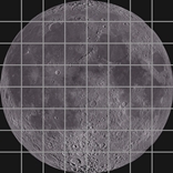
Two maps are available from our site for the exploration of the Moon. A map which is useful for your first steps in the observation, like with binoculars or a small instrument, and a map for further exploration. A lunar nomenclature is available too, which will allow to a better undestanding of lunar terrain features. Do not forget, at last, the fine resource of the Virtual Moon Atlas by Christian Legrand and Patrick Chevalley
| A Map for Your First Steps in The Observation of The Moon A Map for A Further Exploration of The Moon Some Notes About Lunar Nomenclature |
That simple Moon map is a useful tool for your first steps in the observation of the Moon, like with binoculars or a small telescope. That map, on the other hand, has to be considered in evolution as, by intervals, it may be complemented with additional lunar terrain features based on our own low-magnification observations of the Moon. The original picture was published early March 2011 at the NASA site as that global view of the near side had been reconstructed from 1,300 pictures taken by mid-December 2010 by the LRO mission during a duration of 2 weeks (original view courtesy NASA/GSFC/Arizona State University)
. Coordinates: this map is showing North, East, South, and West according to the most simple convention, as they would be termed considering Moon like Earth is seen from afar: North is up, South is bottom, East is right, West is left. The convention was adopted by 1961, by the International Astronomical Union (IAU) as the convention was the reverse before. A usual observing convention is that East and West are inverted: West is considered the limb facing western horizon, that is the limb facing where the celestial sphere is rotating in its daily motion. East is the limb facing eastern horizon. North and South are generally unchanged in this system. As instruments are somehow reverting Moon's image in various ways, North and South in your instruments, West and East (whatever the system defining them is used) may look inverted. Moon Prime Meridian lies on the near side dead full between East and West

For further exploration of the Moon through a instrument, check our 'Moon in 64 Detailed Views,' a useful tool!
Nomenclature: as far as Moon nomenclature is concerned, International Astronomical Union (IAU) official usage is that craters are named from famous deceased scientists, scholars, artists, and explorers, as maria are termed by names describing weather and other abstract concepts. Mountains are termed by names of Earth's mountain ranges or from nearby craters. For daily amateur use, usage mostly is that maria are expressed by their Latin names as mountains and craters are by their name in English. Following list is translating Latin maria names in English, and English mountains names in Latin
| Mare Australe | Southern Sea |
| Mare Cognitum | Sea of Knowledge |
| Mare Crisium | Sea of Crises |
| Mare Fecunditatis | Sea of Fecundity |
| Mare Frigoris | Sea of Cold |
| Mare Humboldtianum | Sea of Humboldt (Alexander von, German natural historian 1769-1859) |
| Mare Humorum | Sea of Moisture |
| Mare Imbrium | Sea of Showers |
| Mare Marginis | Sea of the Edge |
| Mare Nectaris | Sea of Nectar |
| Mare Nubium | Sea of Clouds |
| Mare Serenitatis | Sea of Serenity |
| Mare Smythii | Sea of Smyth (William Henry, British astronomer 1788-1865) |
| Mare Tranquillitatis | Sea of Tranquility |
| Mare Undarum | Sea of Waves |
| Mare Vaporum | Sea of Vapors |
 | click to a additional map of Moon's maria. site 'Amateur Astronomy' |
| Lacus Somniorum | Lake of Dreams |
| Oceanus Procellarum | Ocean of Storms |
| Palus Somnii | Marsh of Sleep |
| Sinus Aestuum | Seething Bay |
| Sinus Iridum | Bay of Rainbows |
| Sinus Medii | Bay of the center |
| Sinus Roris | Bay of Dew |
| Alps | Montes Alpes |
| Apennine Mts | Montes Apenninus |
| Caucasus Mts | Montes Caucasus |
| Haemus Mts | Montes Haemus (a range in the Balkans) |
| Jura Mts | Montes Jura |
| Riphaeus Mts | Montes Riphaeus (a range in Asia, now Ural Mountains) |
| Alpine Valley | Vallis Alpes |
| Rheita Valley | Vallis Rheita |
| Schröter Valley | Vallis Schröteri |